Southwest Connects
Corridor Information
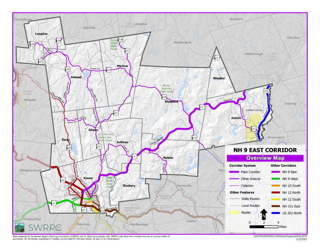
Among the two east-west highways in the Southwest Region–the NH 9 East and NH 101 East Corridors– the NH 9 East Corridor (Corridor) is the east-west highway that is the best suited for promoting regional mobility. This is because, unlike NH 101 East, it bypasses town centers along the way, 64% of abutting land on NH 9 is protected by limited or controlled access regulations by the state, and much of the land use on the highway is in conservation or unsuitable for development due to natural constraints.
The NH 9 East Corridor is one of the most rural corridors in the Southwest Region. Eight of the 12 communities have populations less than 1,000. Outside of Keene, approximately 50% of the population is middle aged (between the ages of 35 to 64). Stoddard has a relatively large population of youth (20%) and seniors (20%). In the 2000s population declined in Alstead, Marlow, Roxbury and Sullivan. Notable population growth occurred in Antrim (188), Keene (846) and Stoddard (304), although this would be considered slow growth in other parts of the country. Population estimates from the NH Office of Energy & Planning predict these three communities to take on the most growth in the coming decades.
The majority of the towns in the Corridor are communities with primarily rural residential housing and very few jobs or commercial development. Eight of the 12 communities in the Corridor have a ratio of five or more housing units for every job in their community. Keene is the top workplace destination for most communities as well as the top destination for shopping, medical services and other basic needs. Communities in this area have some of the most expensive household transportation costs in the Southwest Region. In fact average transportation costs are expected to exceed housing costs in Alstead, Gilsum, Langdon, Sullivan and Windsor.
Priority challenges and opportunities for the NH 9 East Corridor include the following:
- NH 9, as a hilly, curvy high speed rural highway with occasional bad weather has experienced 10 crashes involving highway fatalities (9 in Stoddard) and 38 crashes involving incapacitating injuries from 2002-2010.
- 11.4 miles of NH 9 highway frontage between I-91 and I-89 is not protected by state limited or controlled access regulations. A SWRPC NH 9 Corridor Study, produced in 2006, estimated that up to 62 million square feet of commercial land could be available for development on this stretch of highway which could impede regional mobility if not carefully planned.
- The remote and rural nature of the Corridor, and Corridor residents’ dependence on long distance travel for basic needs makes communities experience some of the highest household transportation costs in the Southwest Region. Seniors, youth and low income populations are disproportionately impacted because of a lack of other transport alternatives or in-town community resources.
- NH 9 parallels some major brooks (Otter Brook and North Branch River) that are limited in their capacity to handle severe storm events and may impact highway and bridge infrastructure.
For more information see the Route 9 East Corridor fact sheet
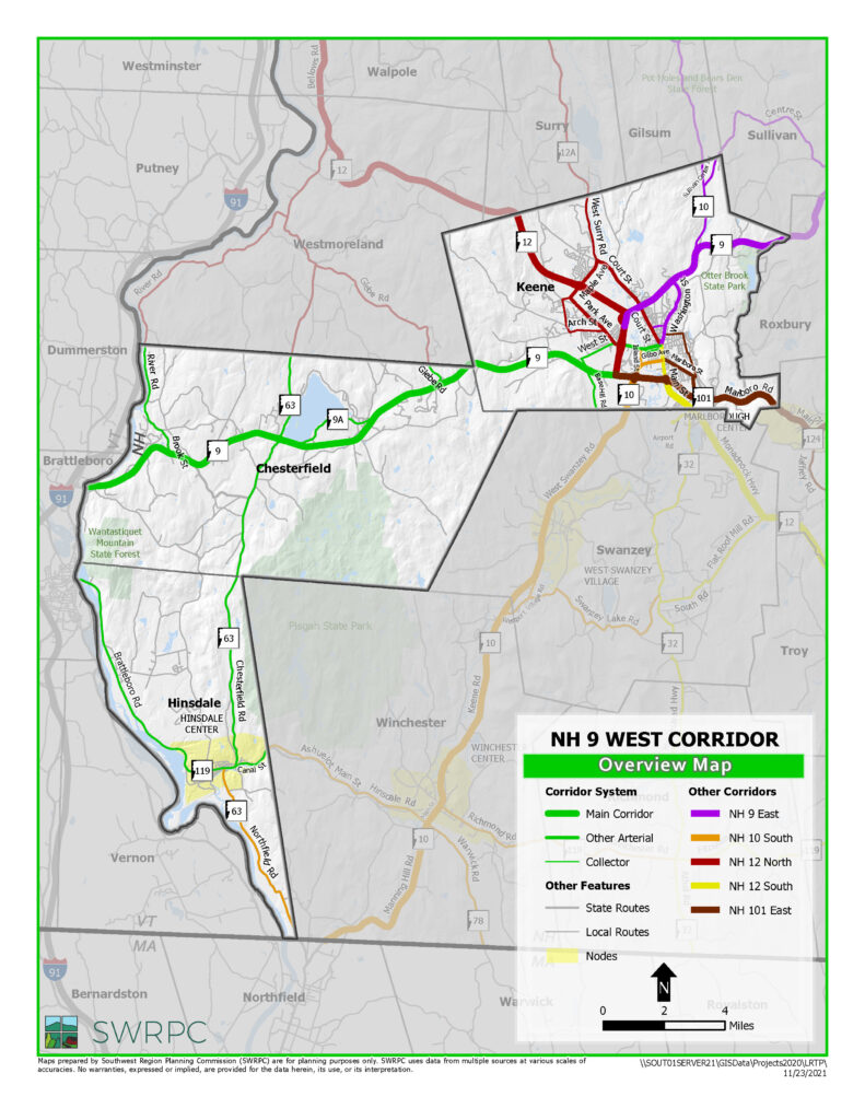
One of the most important regional attributes of the NH 9 West Corridor is that it is a well-built arterial highway that connects the Southwest Region to I-91 and beyond. One hundred percent of the abutting land is protected by state controlled access regulations. Not coincidentally, it is an important freight route carrying about 1,200 to 1,400 trucks daily on some parts of the Corridor. There are also approximately 2,300 residents that live on the corridor and work at one of the other municipalities on the Corridor. Some of the significant employers on the Corridor system include United Natural Foods in Chesterfield (300 employees), a Super Walmart in Hinsdale (230 employees) and National Grange Mutual Insurance in Keene (347) on West Street which is considered part of the NH 9 West Corridor.
Significant nodes on the Corridor include Downtown Keene and Downtown Hinsdale, both of which today each have local transit service and good sidewalk systems. Though not part of the Corridor system, Brattleboro, Vermont is another important node. In fact many Hinsdale residents work, shop and receive services in Brattleboro. In addition to roads, transit and sidewalks, there is a park and ride lot at Granite Gorge State Park in Chesterfield, however its location is not ideal for attracting carpool or bus riders. The Corridor also hosts the greater region’s only intercity bus service, which makes a stop in Keene as well as just outside the corridor in Brattleboro, VT.
Hinsdale has slowly lost some of its population in the last ten years, which is predicted to continue into 2040, barring no significant economic development changes in that community. Aside for Keene, roughly 50% of the entire population is middle aged (between the ages of 35 to 64). Downtown Hinsdale has a relatively high proportion of youth (20%) and single parent households (42%). At the time of writing, Hinsdale also has the highest unemployment rate in the Southwest Region at 6.7%.
Priority challenges and opportunities for the NH 9 West Corridor include the following:
- Regional connectivity for Hinsdale to other communities is at risk because of poor highway and bridge infrastructure. The two bridges connecting Hinsdale and Brattleboro, VT were originally constructed in the early 1920s and are well overdue for replacement. NH 63, Hinsdale’s primary link to Keene, is in poor condition. Detours around the bridges and/or NH 63 are both excessive distances.
- There is a great deal of duplicative commuter traffic moving along the corridor between Keene and Brattleboro, VT, however land use patterns in Hinsdale and Chesterfield are such that the communities do not have ideal nodal centers that could be easily integrated into a commuter route for bus or rideshare services between the two cities.
- Chesterfield and Hinsdale’s proximity to I-91 and the New England Central Railroad, transportation-related economic engines, perhaps provide the best position in the Southwest Region for economic growth opportunities. Some new employers have been attracted to the communities’ location at the trisection of New Hampshire, Massachusetts and Vermont including Walmart and Fed Ex. This may become more important as several Corridor communities rebound from the announcement about the pending closure of Vermont Yankee.
For more information see the Route 9 West Corridor fact sheet
The NH 10 South Corridor, like the NH 9 West and NH 12 North Corridors, is important for facilitating traffic flow to and from I-91. SWRPC estimates that at least two thirds of the Southwest Region communities would use NH 10 to reach longer trip destinations to the south and west including trips that extend west via I-90 in Massachusetts and southwest via I-84 in Connecticut. However, during winter month inclement weather, the Manning Hill section of NH 10 South in Winchester is considered less reliable and other corridors may be used as an alternative route.
NH 10 South traffic continues to grow on most parts of the Corridor. At the north end of the corridor from approximately 2005-2011, average annual daily traffic growth grew by 5,000 vehicles near NH 10’s intersection with Kit Street area and by 7,000 vehicles at the intersection of Winchester Street and Key Road. In the 2000s, the corridor saw some of the most housing growth in the 2000s, amounting to 1,175 units total. Anecdotally, it is known that there is a great deal of workforce housing and senior housing in the various communities that were built and driving some of the growth. The corridor is filling a gap in providing some of the affordable housing. Today the corridor has the highest proportion (20%) and highest total of low income population (8,093) compared to all other corridors. Its senior population is average (15%) totaling 5,880 people. Housing development is attractive in the area since the corridor has the least expensive average mortgage housing ownership costs ($1,558) as well as the least expensive median monthly budget ($1,413) needed for transportation of any corridor.
There are a number of significant nodes identified for the Corridor including Downtown Keene, West Swanzey Village, Downtown Hinsdale, and Downtown Winchester. Each nodal area has a sidewalk system in place, but only Keene and Hinsdale have transit service at this time. Although Keene is a dominant destination for shopping and services, many services are available at other nodes. For instance, West Swanzey and Downtown Winchester each have their own supermarkets and Winchester has a health clinic.
Priority issues and challenges for the NH 9 West Corridor include but are not limited to the following:
- The NH 10 Corridor has seen significant traffic increases over time partly due to the fact that Keene continues to develop commercial land in the western part of the City. In the heaviest traffic areas, in Keene, rights of way are severely limited. Although frontage on Keene’s urban compact area is nearly built out, there are still additional locations available for commercial development which could put new pressures on Keene’s urban compact area.
- Though it is an important corridor, only about 20% of the Corridor’s abutting land is protected by state controlled access regulations in the northern Winchester area.
- A NH 10 JARC Study by SWRPC suggests that the NH 10 South Corridor is among the best areas for passenger service development, accommodating population needs in Winchester and West Swanzey (see special population data later in this section).
Maintaining safety in the Manning Hill area will need to continue to be a high priority.
For more information see the Route 10 Corridor Fact Sheet
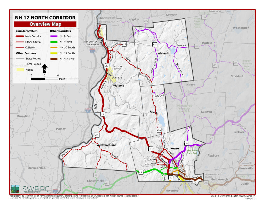
NH 12 North Corridor connects much of the Southwest Region with major northern cities in New Hampshire, Vermont and Canada via I-91. The corridor has the most multi-modal offerings of any corridor in the Southwest Region, hosting Greyhound Bus Lines, Inc. intercity bus route, as well as local transit routes in Keene and Walpole, and passenger and freight rail access in or within walking distance of North Walpole Village. Through the leadership of Keene, regional destinations by rail trail are improving as well, after the City invested in North Bridge, a multiuse bridge that crosses over NH 9/10/12 near West Street.
Much of the Corridor is rural, but there are three nodal centers identified in the corridor including Keene, Walpole Village and North Walpole Village. Though Walpole has a significant number of jobs its housing growth was unusually slow in the 2000’s with only 9 housing permits recorded by the town. Future growth is projected to be slow to moderate in this Corridor, with Alstead perhaps losing population by 2040. Today 46% of the corridor’s population outside of Keene consists of people in their middle age (ages 35-64). However, North Walpole Village has a concentrated high number of special populations including youth, seniors, low income and single parent households. There are a number of senior housing units in Walpole hosted by Southwestern Community Services as well as Cheshire County’s Maplewood Nursing Home in Westmoreland.
Several interesting traffic trends have occurred on the Corridor in recent years. In the past 4-6 years, NH 12 South of Maple Avenue has seen a reduction in average annual daily traffic by 5,000 vehicles, possibly due in part to the closure of the Fed Ex facility just North of that location. During that same time period North Walpole village has seen its use of the Arch Bridge increase by over 7,200 vehicles daily after the closure of Vilas Bridge. More traffic is expected on NH 12 in Walpole as a number of new retail establishments have replaced former open space and farmland along the highway.
Priority challenges and opportunities for the NH 12 North Corridor include the following:
- The closed Vilas Bridge, closed today, will require more cooperation and coordination with Vermont. Many in New Hampshire are seeking a higher contribution from Vermont.
- This Corridor, which includes the Connecticut River watershed has suffered greatly in recent years from severe storm events impacting NH 12 South, NH 123, NH 63, several bridges and the Cheshire Rail Trail. Some infrastructure has been upgraded but other infrastructure needs maintenance or upgrades to prevent dangerous and costly future impacts.
- The New England Central Railroad presents itself as a challenge and perhaps an economic opportunity for the NH 12 North Corridor with its at-grade crossing in North Walpole, its bridges that constrict traffic in North Walpole and Westminster, VT and its sidings in North Walpole.
- Population data suggests that planning attention may be required for North Walpole Village.
- Retail growth on NH 12 in Walpole, which has been enabled by connections to Rockingham, VT sewer has implications for mobility and safety on that portion of the corridor.
For more information see the Route 12 North Corridor fact sheet
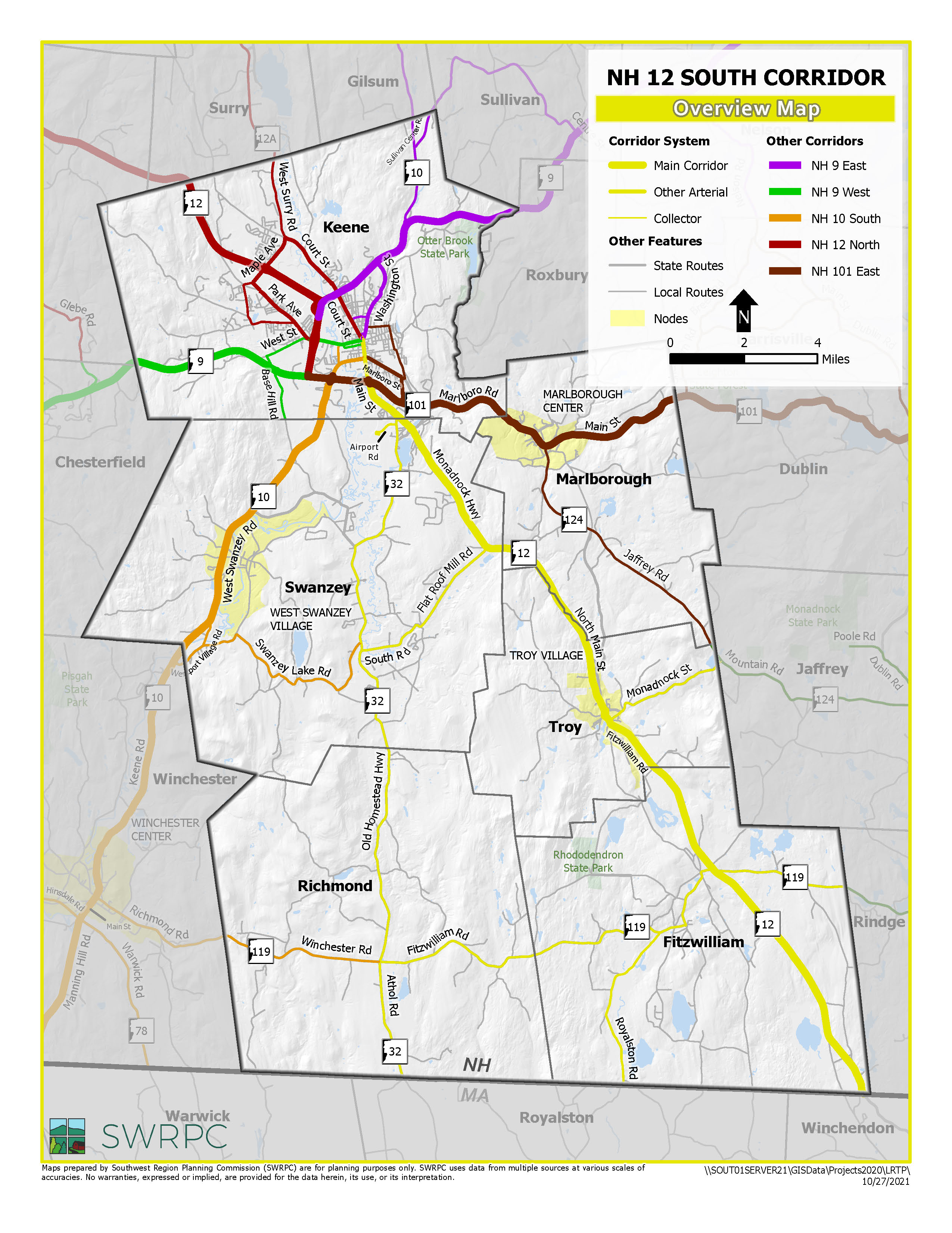
The NH 12 South Corridor connects the western part of the Southwest Region with destinations in Massachusetts and beyond via the limited access highways MA 2, I-495 and I-95. Along with NH 9 and NH 101, this Corridor is designated part of the National Highway System. The Cheshire Branch Rail Trail parallels the Corridor all the way from Keene to Fitzwilliam, much of it in fair to good condition, although the crossing from downtown Keene to the trail requires bicyclists and pedestrians to use extra care crossing NH 101. The NH 12 South Corridor hosts the only public airport in the Southwest Region at Dillant-Hopkins Airport located in Swanzey, which is only a short distance off NH 12. This airport caters mostly to business and recreational aviation needs.
The two nodal centers present on this corridor include downtown Keene and downtown Troy. Marlborough is included as part of the corridor, but very little of the town has frontage on NH 12 itself, and Marlborough Village Center is part of the NH 101 East Corridor. Outside of Keene, 46% of the corridor’s population are middle-aged (between the ages of 35 and 64). However, there are a fairly high proportion of youth in Richmond (22%), Troy (21%) and Troy Village (23%), as well as single parent households in Downtown Troy (40%).
Traffic growth on the corridor has been slow to moderate over the last several years with most of the higher traffic levels growing in the vicinity of Keene. Truck traffic on the corridor is significant. An SWRPC traffic count in August 2013 found that 13% of approximately 9,000 vehicles at the Marlborough and Troy town line were medium or heavy duty trucks. Housing unit growth during the 2000s was strongest in Keene (379) and Swanzey (392) and Fitzwilliam (138) while the other communities had modest growth (averaging 68). Overall, the corridor population is projected to grow 5% between 2010 and 2040. Today most jobs on the corridor are in Keene and Swanzey. Fitzwilliam, Richmond and Troy have at least 5 housing units for every community job.
Priority challenges and opportunities for the NH 12 South Corridor include the following:
- Ongoing coordination is warranted with stakeholders in Massachusetts to monitor change happening between the NH/MA state line and MA Route 2. SWRPC has a strong interest in maintaining mobility.
- There are several locations on the corridor where towns, SWRPC, NHDOT and landowners will need to coordinate local, regional and state interests. Areas need special attention include Lower Main Street in Keene, the intersection of NH 32, the Cheshire Fairgrounds/TIF District in Swanzey, downtown Troy and the intersection of NH 119 and NH 12 in Fitzwilliam.
- More assessment is likely required to maximize the regional economic benefit of the Dillant-Hopkins Airport.
- The Cheshire Branch Rail Trail is in fair to good shape through most of the corridor area. Spot trail improvements, regional cooperation and marketing could improve recreation and economic development opportunities for area towns.
For more information see the Route 12 South Corridor fact sheet
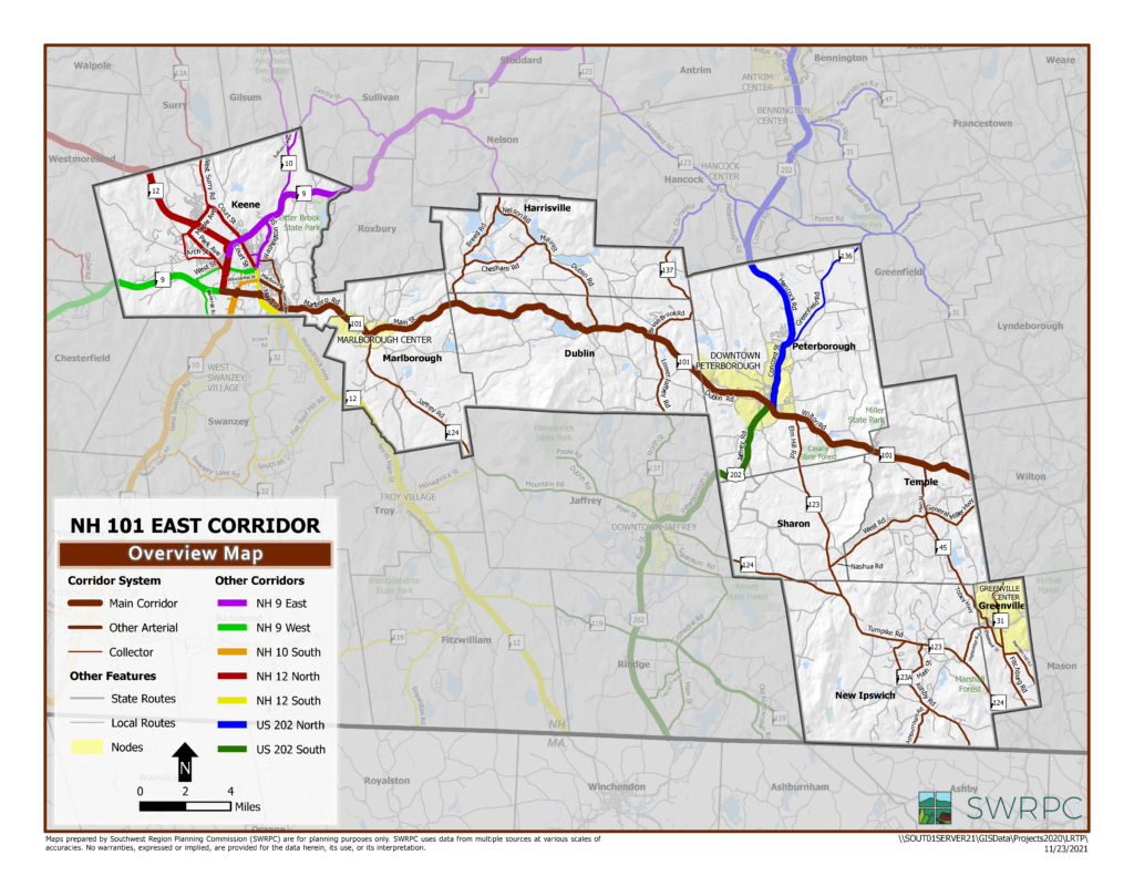
The NH 101 East Corridor, designated as part of the National Highway System, is an important east-west highway in the Southwest Region connecting the region to Manchester, Nashua and I-93. It is used frequently by communities having origins or destinations in the southern half of the Southwest Region, however, communities with origins or destinations to the south and west of Keene may prefer using the NH 9 East Corridor. There are a number of characteristics along the NH 101 Corridor that sometimes delay traffic including village centers in Marlborough and Dublin, mountains in Marlborough, Dublin, Peterborough and Temple, and a stop light in Peterborough. Passenger transportation and rail trail options are extremely limited on the NH 101 Corridor, but available.
Like most communities in the Southwest Region there is a large proportion of middle age people residing (ages 34-65) on the NH 101 Corridor, and some communities, such as Harrisville, Sharon and Temple the proportion of middle aged populations is above 50%. Downtown Greenville has the highest geographic concentration of youth (age 15 and under) at 20%. Downtown Greenville and Temple were found to have relatively large proportion of low income people in their communities (30% and 25% respectively). Downtown Greenville also has a high proportion of single parent households (46%). Though not excessively high, several communities had moderately high unemployment rates in the corridor including Greenville (6.5%), Temple (6.5%) and New Ipswich (6.1%).
Traffic has not grown significantly on any part of the NH 101 Corridor in the 2000s, and in some cases it has decreased. The highest levels of traffic, above 10,000 AADT, are in Keene. Peterborough’s traffic on NH 101 West of Grove Street was 9,100 AADT in 2012. The fastest growing communities on the corridor are New Ipswich, Keene and Peterborough. Those three municipalities issued 420, 379 and 260 housing permits respectively during the 2000s. Each of those communities are also projected to lead the other communities in future population growth, accounting for 97% of the growth of the entire corridor by 2040. Meanwhile, other communities are expected to lose population or to have relatively flat growth such as Greenville, Harrisville, Marlborough and Sharon. Keene, Peterborough and New Ipswich also lead by leaps and bounds in the number of jobs offered on the Corridor.
Priority challenges and opportunities for the NH 101 East Corridor include the following:
- Many parts of the Region are extremely rural and isolated. There will need to be persistent push to continue improving alternative passenger transportation options on the Corridor.
- Maintaining winter safety in the mountainous parts of the NH 101 highway corridor (Hurricane Hill, Pack Monadnock and Temple Mountain on NH 101 and Mount Monadnock on NH 137) will need to continue to be a high priority.
- Intercity bus services used to connect Peterborough with Keene and the I-93 communities which may need to be assessed again.
- The former Manchester and Keene Branch Rail Trail is an asset that deserves more attention.
For more information see the Route 101 East fact sheet
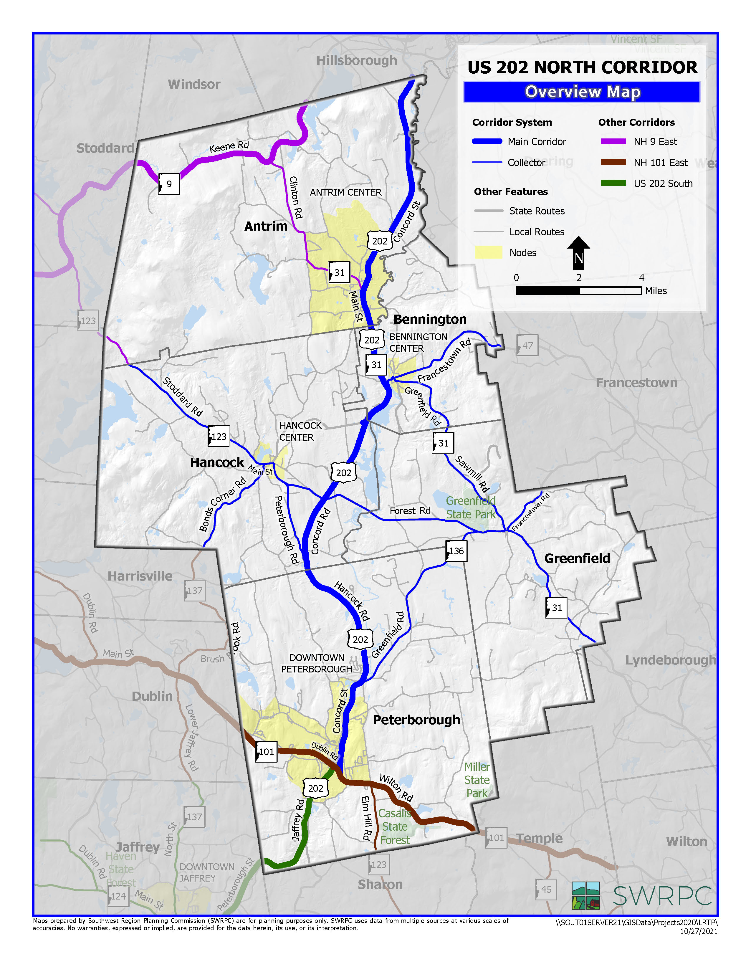
The US 202 North Corridor is the north-south arterial of choice in the eastern part of the Southwest Region, providing connections to the NH 9 East Corridor to the north and the US 202 South Corridor and NH 101 East Corridor to the south. Much of the road meets modern arterial highway standards with twelve foot wide travel lanes and eight foot wide shoulders. Lanes and shoulder widths reduce as the highway passes through two of its nodal centers, Downtown Peterborough and Downtown Antrim. The other two nodal areas on the Corridor, Hancock Village and Downtown Bennington, are bypassed by US 202 itself. All nodal centers have sidewalk infrastructure, particularly towards the centers of each community. Although some passenger transportation services are available in this area, they are very limited. Two rail trails, Peterborough’s Common Path and the Hillsborough-Bennington Trail parallel US 202 and are recognized as part of the US 202 Corridor System. In addition, the US 202 North Corridor has active rail on the short line Milford-Bennington Railroad, which is owned by the State of New Hampshire. The Hawthorne-Feather Airport, just outside of the Corridor area, is nearby in Hillsborough.
In the 2000s, the most housing permit activity occurred in Peterborough (260), Antrim (149) and Greenfield (111). By 2040 all corridor communities are predicted to grow 8-10% with the exception of Hancock which is expected to lose about 3% of its existing population. Today the US 202 North Corridor has a relatively high proportion of seniors, especially in Hancock Village and Downtown Peterborough (28% and 26% respectively). However, there are significant proportion of youth (age 15 and under) and millenial populations in Downtown Bennington (26% and 27% respectively). The proportion of single parent households is also very high in Downtown Bennington (54%). Community housing to job ratios are quite balanced, with the exception of Francestown which has 10 housing units for every job and Hancock, which has 6 housing units for every job. A number of large employers are part of the US 202 Corridor System including Crotched Mountain (900 employees) and Monadnock Community Hospital (668 employees).
Priority challenges and opportunities for the US 202 North Corridor include the following:
- Francestown has an inordinate number of municipal red list bridges. Some of these bridges will be addressed in the next few years, but there are several additional bridges that need to be rehabilitated or reconstructed.
- The Milford-Bennington Railroad represents a potential economic development opportunity for the Region. At the time of writing there is no railroad operating on the rail corridor.
- US 202 North area is ranked as one of the most expensive transportation corridors for households. Passenger transportation services, such as vanpools and carpools should be explored to help households save money.
- This corridor has the highest proportion of seniors of any corridor (17%). Although the entire population on the corridor is small, the high transportation household cost this may be a corridor that requires more targeted assistance to seniors.
For more information see the Route 202 North Corridor fact sheet
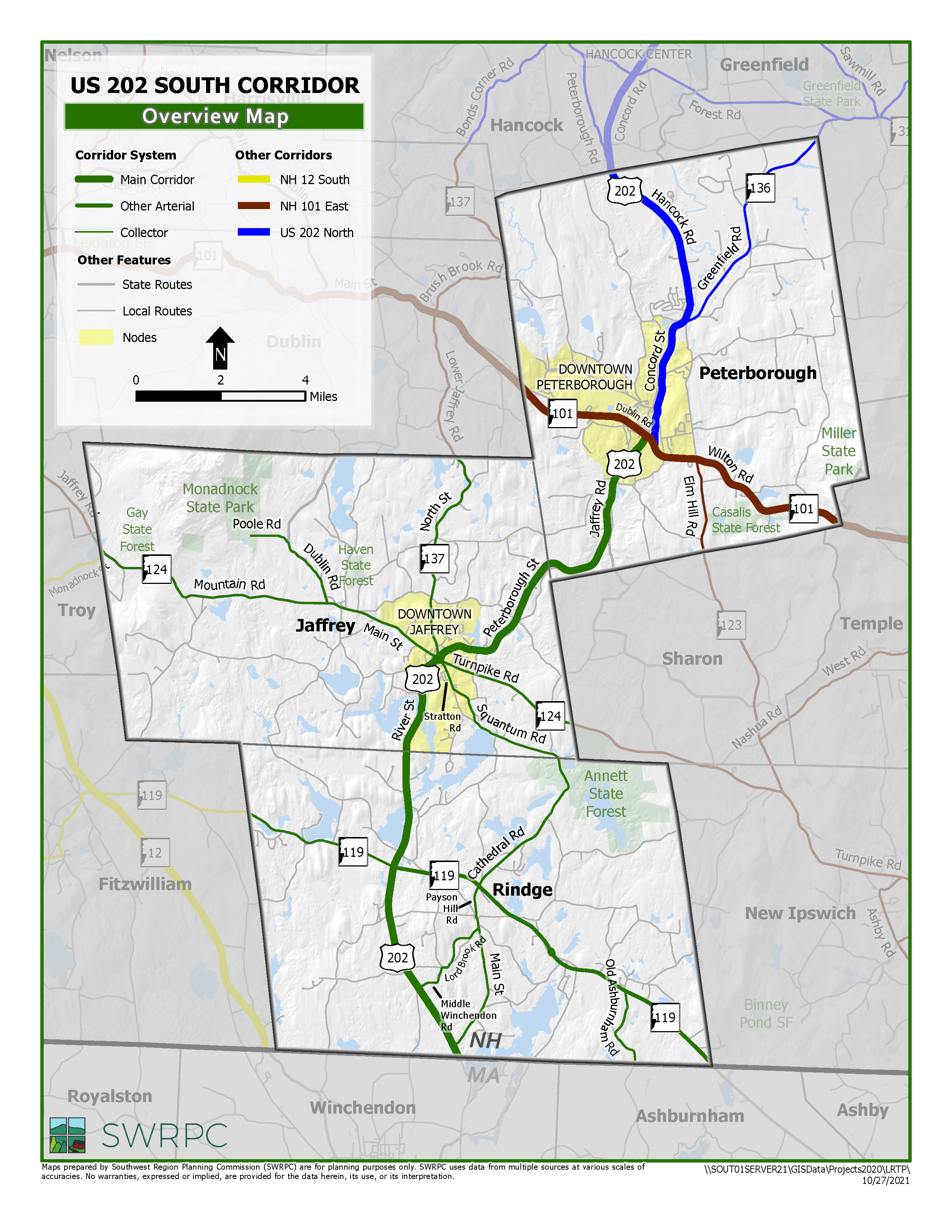
Like the NH 10 and NH 12 Corridors, the US 202 South Corridor is one of the arterials in the Southwest Region that connects several Southwest Region communities to Massachusetts. It is particularly important to southern Peterborough, Jaffrey and Rindge, three of the most populous communities in the Southwest Region and host to a number of important employers including Millipore (700 employees), NH Ball Bearings (550 employees), Teleflex Medical (303 employees) and Franklin Pierce University (300 employees). Passenger transportation services are very limited on the corridor, but there are some services. Peterborough’s Common Path parallels the northern portion of the Corridor down to Noone Falls. The same rail right of way picks up again in downtown Jaffrey north of US 202/NH 124 intersection and continues south all the way through Rindge in Massachusetts where it abruptly ends in Winchendon, MA.
In the 2000s, Jaffrey’s population decreased a small number, while Peterborough and Rindge’s population increased by 6.8% and 10.3% respectively. Despite Jaffrey’s population loss, it recorded demand for 204 housing permits. Noteworthy special populations on the Corridor include Jaffrey’s youth (21% of the community), Rindge’s millennials from Franklin Pierce University (37% from that community) and relatively high number of single parent households in downtown Jaffrey (47%). Peterborough’s senior population is substantial on the corridor, probably because of the presence of Rivermead, a retirement community in southern Peterborough off of US 202.
Traffic volumes have remained relatively steady, with the highest traffic levels in downtown Jaffrey (13,000 AADT), a mix of local and regional traffic. Traffic volumes in Peterborough on the 12,000 near the NH 101 intersection to 9,000 AADT near Sharon Road. In Rindge, traffic volumes hover between 5,500 at the MA State Line to 9,100 AADT just south of NH 119.
Priority challenges and opportunities for the US 202 South Corridor include:
- The Jaffrey dog-leg area in downtown Jaffrey remains a significant challenge for this corridor. The intersection has a number of issues including high delays at traffic lights, limited maneuverability for trucks negotiating the intersections, extra wide streets making it difficult for pedestrian crossings, a lack of parking, confusing routing, and other concerns.
- The Town of Rindge is interested in making West Rindge into a traditional village. This will require close coordination between the town and NHDOT.
- The Rail Trail breaks up between Peterborough and Jaffrey. Yet there are a number of potential users of a recreational rail trail in the connecting area including residents of Rivermead and employees of NH Ball Bearings and Staff Development for Educators.
- There are a number of bus/shuttle-like transportation services that use this Corridor, however they do not market themselves to the general public. There may be an opportunity to connect people to Downtown Jaffrey, Downtown Peterborough and shopping in Rindge.
For more information see the Route 202 South Corridor fact sheet